// 2026-06-24 · Maps & Exploration · by Bob Smith
OCEARCH Shark Tracker: Follow Real Sharks by Name
The OCEARCH Shark Tracker maps tagged sharks in near real time, each one named, with a profile. Watch a great white cross an ocean. Free and weirdly personal.
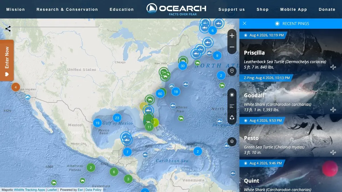
The OCEARCH Shark Tracker is a live-ish map of real sharks with real names. Researchers tag them, the tags ping satellites when a fin breaks the surface, and the whole thing gets published on a public map that anyone can watch. You will start out curious about sharks in general and end up checking on one specific shark like she is a relative. It is free, and it is one of the best things science has put on the open web.
What is the OCEARCH Shark Tracker?
OCEARCH is a nonprofit ocean research organization. It runs expeditions, catches large marine animals, works them up on deck in a matter of minutes, attaches a satellite tag, and releases them. That is the science. The tracker is what happens when you decide the resulting data should not sit in a spreadsheet.
Every tagged animal gets a name and a profile, species, sex, length, weight, where it was tagged, and its accumulated track. Then the map does the rest. Dots appear where the animal has surfaced, lines connect them, and slowly a story emerges: this one hugs the coast, that one crossed open ocean, this one has been in the same bay for a month.
The naming is the masterstroke. A dot labeled “shark #4471” is data. A dot labeled with an actual name, attached to a photo and a length in feet, is a character. People check on their favorite sharks. People notice when one goes quiet. It turns migration ecology into something you follow rather than something you read.
And the tracks themselves are genuinely astonishing. Some of these animals cross ocean basins. Some return to the same stretch of coast year after year with unnerving precision. Watching that draw itself out over months is a slow-motion nature documentary that nobody edited.
What can you do on the tracker?
- Browse the map. Zoom anywhere in the world and see which tagged animals have reported nearby.
- Pick a shark and follow it. Open a profile, look at its history, then come back in a few weeks and see where it went.
- Filter by species. Great whites get the attention, but there is more in the water than that. Filter down and go looking.
- Read the tag dates. Each ping is timestamped, and the gaps between them tell you as much as the positions do.
- Check your own coastline. Everyone does this. It is fine. Yes, they were probably already there.
- Use the app. OCEARCH offers free mobile apps if you want the tracker in your pocket.
Tips to get the most out of it
Understand what a ping is before you panic. A ping only happens when the dorsal fin stays above water long enough for the tag to talk to a satellite. No ping does not mean the shark is gone, it means she has been swimming below the surface, which is what sharks mostly do.
Do not read the dots as a live position. The most recent ping is where the animal was when it last surfaced. It could be very far from there now. This is a trail of breadcrumbs, not a radar screen.
Adopt one animal and be patient. The tracker rewards return visits far more than it rewards one long session. Pick a shark, bookmark it, check monthly. The track over a year is the actual content.
Read the profile before the map. Knowing an animal’s length, where it was tagged and when makes every subsequent dot mean something. Skipping straight to the map is like watching a match without knowing the teams.
Compare two animals of the same species. Nothing kills the “sharks just swim around randomly” idea faster than seeing two great whites make wildly different, entirely consistent journeys.
Bring it to anyone who is scared of sharks. Names, faces and travel diaries do more for public perception of a misunderstood predator than any amount of arguing.
If you like the OCEARCH Shark Tracker, also try…
- MarineTraffic: the same satisfying dots-on-an-ocean feeling, except the dots are enormous cargo ships you can look up by name.
- Flightradar24: watch essentially every aircraft in the sky right now, and click any one of them for its story.
- Explore.org Live Cams: free live nature cameras, including underwater feeds, for when a map is not enough and you want to actually see the water.
- Windy: gorgeous animated weather and ocean layers, useful context for why an animal went where it did.
More trackers and globes in our Maps & Exploration collection. Then go find a shark on the OCEARCH Shark Tracker and check her coordinates. She has been busy.
Frequently asked questions
What is the OCEARCH Shark Tracker?
The OCEARCH Shark Tracker is a public map showing the movements of marine animals that the research organization OCEARCH has tagged, most famously great white sharks. Each tagged animal has a name and a profile page, and the map plots its reported positions over time. It exists so that the scientific data OCEARCH collects is visible to anyone, not just researchers.
Is the OCEARCH Shark Tracker free?
Yes. The tracker is free to use on the web with no account required, and OCEARCH also offers free mobile apps. The organization is a nonprofit funded by partners and donations rather than by charging for access to the data.
How does shark tracking actually work?
Tagged sharks carry a transmitter attached to the dorsal fin. When the fin breaks the surface for long enough, the tag sends a signal to a passing satellite, which produces a location fix known as a ping. Because sharks spend most of their time underwater, pings are irregular, which is why a shark can appear to vanish for weeks and then reappear hundreds of miles away.
Does the tracker only show great white sharks?
No. Great whites are the headline animals, but OCEARCH tags a range of species over the course of its expeditions, and the tracker lets you filter by species so you can follow whichever animals interest you. Each tagged animal gets the same treatment: a name, a profile and a track on the map.