// 2026-06-16 · Maps & Exploration · by Bob Smith
The True Size Of: See How Badly Maps Lie to You
The True Size Of lets you drag countries around a world map to compare them properly. Greenland is not the size of Africa, and you can prove it in ten seconds.
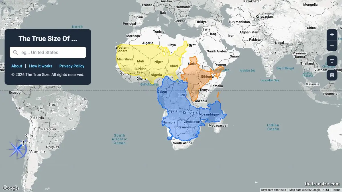
The True Size Of is an interactive world map that lets you pick up a country and drag it anywhere you like. As you move it toward the equator it shrinks, and as you move it toward the poles it grows, because that’s what the Mercator projection has been quietly doing to your mental image of the planet your entire life. Drag Greenland down onto Africa and watch it shrivel. It takes ten seconds and it rearranges your head.
What is The True Size Of?
Here’s the problem it solves, in the site’s own words: it is hard to represent our spherical world on a flat piece of paper. The most popular projection, Mercator, exaggerates the size of countries nearer the poles while downplaying those near the equator.
The classic example is Greenland. On a Mercator map it looks roughly the same size as Africa. In reality Africa is nearly 14.5 times larger, about 11.6 million square miles to Greenland’s 0.8 million. That is not a small error. That is a wildly, comically wrong picture of the world, and it’s the picture almost everyone carries around.
The True Size Of doesn’t lecture you about this. It just lets you drag the shapes around until you work it out yourself, which is a thousand times more effective. It was built by James Talmage and Damon Maneice, inspired by Kai Krause’s “The True Size of Africa” infographic and, of all things, an episode of The West Wing.
What can you do on The True Size Of?
- Search and drag any country. Type a name, it appears as a colored outline, and you can pull it anywhere on the globe.
- Go beyond countries. States, provinces and regions work too, so you can find out how Texas stacks up against France, or whether your home county would fit inside a national park.
- Rotate the shapes. You can spin a country as well as move it, which matters for long, thin ones: rotating Chile to lie across Europe is a genuinely useful thing to do.
- Stack several at once. Drop three or four countries onto the same continent and watch them all resize independently as you shuffle them around.
- Run the popular comparisons. The site lines up the greatest hits: Greenland vs Africa, Greenland vs the United States, Japan vs the United Kingdom, Russia vs Canada, Brazil vs Australia, Australia vs India, so you can go straight to the ones that break people’s brains.
Tips to get the most out of it
Start with Greenland and Africa, then don’t stop there. The Greenland demo is famous, but the sneaky one is Russia. Drag it to the equator and watch the world’s largest country deflate into something much less imposing.
Try your own country against somewhere unexpected. Everyone has an intuition about how big home is. Dragging the UK onto the American Midwest, or Germany onto Australia, is how you find out that intuition was nonsense.
Rotate before you judge. Chile, Norway and Japan are all long and thin, and their true size is unreadable until you turn them sideways and lay them across something familiar.
Use it live in an argument. This site is unbeatable ammunition. Nobody wins the “Africa is way bigger than you think” debate against a person who can just show them.
Bring it to a classroom. It was explicitly built as a tool for educators, and it lands harder than any static comparison chart because the students do the dragging themselves.
If you like The True Size Of, also try…
- Scale of the Universe: the same “your sense of size is broken” revelation, applied from atoms to galaxies.
- If the Moon Were Only 1 Pixel: a to-scale map of the solar system that requires an exhausting amount of scrolling.
- OldMapsOnline: centuries of historical maps, all searchable by place.
- Our World in Data: for when you want the numbers behind the geography.
Keep exploring in Maps & Exploration and Learning & Education.
Open The True Size Of, grab Greenland, and drag it south. Watch it disappear.
Frequently asked questions
What is The True Size Of?
The True Size Of is a free interactive map tool that shows how badly the Mercator projection distorts the relative size of countries. You search for a country, state or region and drag it around the map, it grows or shrinks as it moves toward or away from the equator, revealing its actual size compared to wherever you've dropped it.
Is The True Size Of free?
Yes, it is completely free to use in a browser with no account required. It was built as an educational tool and teachers use it widely in geography lessons.
Is Greenland really as big as Africa?
No, not remotely. On a Mercator map they look comparable, but Africa is nearly 14.5 times larger, roughly 11.6 million square miles against Greenland's 0.8 million. Dragging Greenland down to the equator on The True Size Of shows the difference collapsing in real time.
Why does the Mercator projection distort country sizes?
It is hard to represent a spherical world on a flat piece of paper, and every projection makes a trade-off. Mercator preserves angles and shapes for navigation, but the cost is that it stretches landmasses near the poles and shrinks those near the equator, so Greenland, Russia and Canada all appear far larger than they really are.