// 2026-08-05 · Maps & Exploration · by Bob Smith
ShadeMap: See Exactly Where the Shadows Fall, at Any Hour of Any Day
ShadeMap simulates sun and shadow on a world map for any date and time, using terrain and building data. Free to use for checking light before you commit.
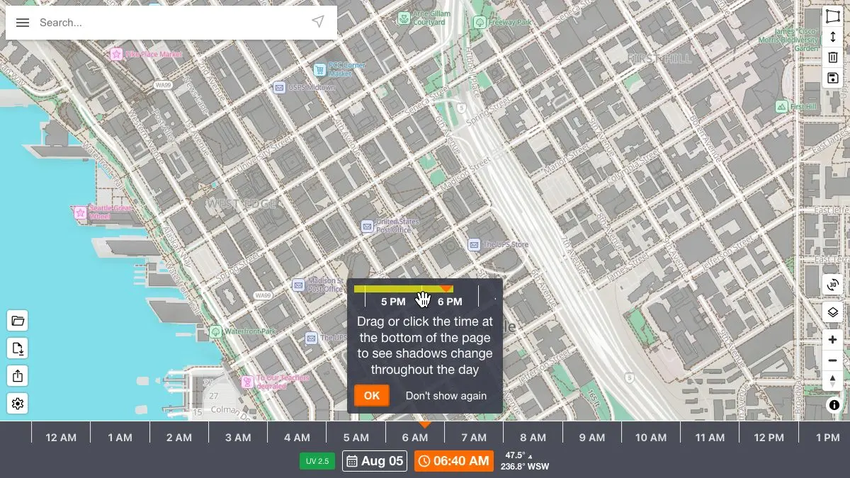
ShadeMap answers a question that ordinary maps simply refuse to engage with: where will the shadow be at four in the afternoon on the third of March? Pick any spot on Earth, drag a slider, and watch the shade sweep across streets, hillsides, and rooftops in real time. It is the kind of tool you open for one specific reason and then keep open for an hour, moving the sun back and forth over your own neighborhood.
What is ShadeMap?
Sunlight is one of the most consequential facts about a place and one of the hardest to check remotely. Estate agents describe apartments as “bright.” Garden centers tell you a plant needs six hours of sun. Photographers plan around golden hour. All of these depend on where the light actually lands, and until recently the only way to find out was to stand there and wait.
ShadeMap does the geometry for you. The sun’s position for any moment at any latitude is a solved problem, computable to a fraction of a degree. Combine that with a digital elevation model for the terrain and building footprints and heights from OpenStreetMap, and you can render the shadow of the physical world onto a map. That is what the site does, worldwide, in the browser.
The interface is deliberately minimal: a map, a time-of-day slider, a date control, and a shadow layer that redraws as you scrub. Move to noon and the shade shrinks to nothing. Move to seven in the evening in October and long fingers of darkness stretch east across everything. In mountainous terrain the effect is dramatic, whole valleys go dark hours before sunset, and you understand instantly why one side of a ridge has a village and the other does not.
In areas with good data it also accounts for tree canopy, which matters enormously if you want to know whether a particular corner of a yard will ever get sun. Coverage varies by region.
There is a paid tier for people who need more: longer date ranges, sun-exposure calculations, and a browser extension that puts the shadow layer over Google Maps. But the free map is not a crippled demo. It is the actual thing, and for most questions it is entirely sufficient.
What can you do with ShadeMap?
- Scrub through a day. Drag the time slider and watch shadows rotate and stretch across a real neighborhood, at whatever zoom level you like.
- Change the date. Compare the same location in December and June. The difference in a north-facing courtyard is often the difference between livable and grim.
- Check an apartment before you view it. Find the building, set the time to when you are actually home, and see whether “bright and airy” survives contact with geometry.
- Plan a garden. Work out which beds get morning sun, which get afternoon sun, and which get a few hopeful minutes in July.
- Scout a photo or film location. Know in advance when a facade will be lit, when a street will be in full shade, and how long you have.
- Assess a roof for solar. See how neighboring buildings and terrain shade a roof across the seasons before anyone climbs a ladder.
- Understand mountain terrain. Ski touring, hiking, and climbing all change character depending on which aspect stays frozen.
- Overlay it elsewhere. The paid extension brings the same shadow layer to Google Maps.
Tips to get the most out of it
Check the solstices, not today. The two dates that matter are around June 21 and December 21, the extremes of the sun’s yearly path. If a spot works on both, it works. Checking a random day in April tells you much less than you think.
Zoom in before you trust the buildings. Building shadows are only as good as the building data. Zoom to street level and check whether the shapes match reality, especially where a new tower may not be in OpenStreetMap yet.
Watch the shade move rather than reading a snapshot. Scrubbing the time slider back and forth tells you far more than any single frame. You are looking for the moment the shadow crosses the thing you care about.
Remember what is not modeled. Fences, awnings, a single very large tree in a neighbor’s yard, none of these are guaranteed to be in the data. Treat the result as the best case for light, then subtract.
Use it for routes as well as buildings. Cyclists and runners in hot climates can plan a route that stays on the shaded side of the street, which sounds fussy until you have done it once in August.
Combine it with a weather layer. Shadow tells you where the sun can reach. It has nothing to say about whether there will be any sun that day.
If you like ShadeMap, also try…
- Ventusky: the other half of the question, gorgeous animated forecasts of what the sky is actually doing.
- Windy: every weather model layer you could want, on one very fast map.
- Falling Fruit: a global map of foraging spots, for when you have solved sunlight and moved on to fruit.
- The True Size Of: a reminder that maps distort things, dragged interactively across the globe.
More cartographic time sinks in Maps & Exploration, and more single-purpose problem solvers in Tools & Utilities.
Frequently asked questions
What is ShadeMap?
ShadeMap is a web map that draws the sun's shadows over real terrain and buildings for any location on Earth. You pick a place, then drag a slider to move through the hours of the day or change the date, and the shaded areas update in real time. It is used for everything from picking a garden bed to scouting photo locations to sanity-checking an apartment listing.
Is ShadeMap free?
The core map is free to use in a browser with no account. There is a paid tier that unlocks extra features such as longer date ranges and sun-exposure analysis, but the basic shadow simulation that most people come for costs nothing.
How accurate is ShadeMap?
It calculates the sun's position astronomically, which is exact, then casts shadows using elevation models and building height data from open sources. Terrain shadows in mountainous areas tend to be very reliable. Building shadows depend on how well that specific block has been mapped, so a newly built tower or an unmapped extension may be missing.
Can I use ShadeMap to plan solar panels or a garden?
It is a strong first pass. You can see how a roof or a plot is shaded across the day and across the seasons, which is usually enough to rule locations in or out. For a final decision on solar installation, follow it up with an on-site assessment, since local obstructions like a neighbor's tree may not be in the underlying data.